Wind Chill Chart
Updated October 27, 2001
Beginning November 1, 2001, the National Weather Service will
be using a revised Wind Chill Chart. The NWS felt the need to
have a standardized Index for the US and Canada. The old WCT Index
was based on the 1945 Siple and Passel index. This new chart makes
use of advances in science, technology, and computer modeling
to provide more accurate calculations of winter temperature dangers.
After the February 2001 meetings, Canada and the US agreed on
a new wind chill formula which will be the new standard. It is
based on the following:
- wind speed calculated at the average height (5 feet) of the human
body's face instead of 33 feet (the standard anemometer height);
- a human face model;
- incorporate modern heat transfer theory (heat loss from the body
to its surroundings, during cold and breezy/windy days);
- lower the calm wind threshold to 3 mph;
- a consistent standard for skin tissue resistance; and
- assume the worst case scenario for solar radiation (clear night
sky).
NOTE: In 2002, adjustments for solar radiation for sunny, partly sunny
and cloudy days will be added to the calculations
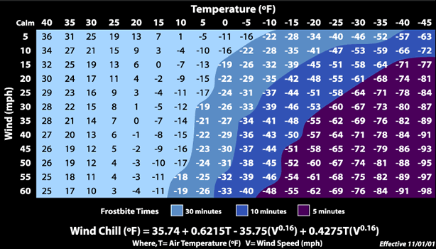
THE NEW CHART
Wind chill temperature is defined as that temperature in calm
air which provides the same chilling effect on a person as that
for a particular combination of temperature and wind. The chart
below allows you to estimate the wind chill temperature for a
variety of temperature and wind speeds. For example, if the temperature
is 30oF and wind speed 15 mph, it will feel like it's 19oF.
Besides being more accurate, the most important feature of this
new Wind Chill Index is showing frostbite danger temperatures
- an indicator of how to dress properly for winter weather. Wind
chill does not affect your car's antifreeze protection or freezing
of water pipes, etc. In dressing for cold weather an important
factor to remember is that entrapped insulating air warmed by
body heat is the best protection against the cold. Consequently,
wear loose-fitting, lightweight, warm clothing in several layers.
Outer garments should be tightly-woven, water-repellent and hooded.
Mittens snug at the wrist are better protection than fingered
gloves.
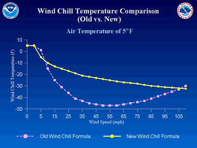
In the old scale, using the same 30oF temp and 15 mph wind speed, the old chart shows it would feel
like 9oF. So the new chart indicates it feels 10oF warmer than the old scale.

Below you can see how the two Wind Chill Charts compare:
This information may be used by you freely for noncommercial use
only with
my name and email address attached.
hollydeyo@standeyo.com
http://standeyo.com
Contents © 1997-2004 Holly Deyo. All rights reserved.
|